


Descripción
El Manatí Tankah: It is located in the Municipality of Tulúm, it is located at the GPS coordinates: Longitude (dec): – 87.392500. Latitude (dec): -20.278889. It is located within the tourist area known as the Riviera Maya, the closest land route is the Federal Highway Km. 240 + 210. “El Manatí” It is 130 km from Cancun International Airport (CUN), 10 Kilometers from Tulúm and 56 Kilometers from Playa del Carmen.
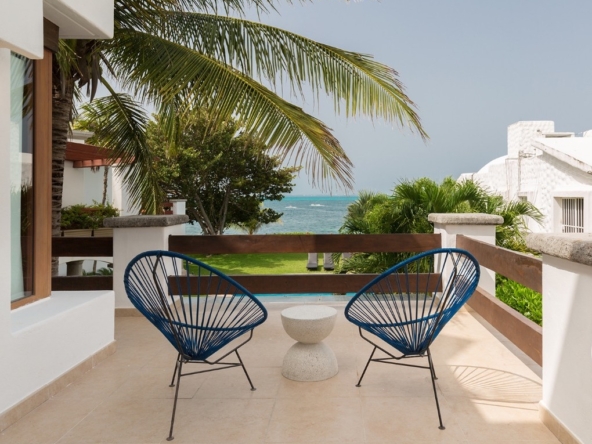
El Manatí Tankah: Known for its white sand coasts, crystal clear waters and its coral reefs, which is part of the Mesoamerican Reef System, the second largest reef in the world, it has been chosen as one of the
Cenote “El Manatí” is the 2nd largest cenote in the Riviera Maya. “El Manatí” has 3 caverns and one of them opens to the sea.
The Turquesa Cenote communicates with the El Manatí Cenote, through underground rivers with Zero Contamination, both cenotes and its spectacular Virgin Beach.
It is located to the south of the property.
The property has a surface water body, with underground communication, of 120 meters. long (20 meters long in its widest part with 30 meters wide) and 100 meters in its narrowest part (4 meters wide).
An average depth of 6 meters.
This body of water communicates through an underground river to the sea, so there is constant migration of fish.
Location: Land called “El Manatí” Located at Km. 240 + 210 in Tankah (Riviera Maya). of the Municipality of Tulúm, in the State of Quintana Roo. Mexico.
Total Area: 3,279,332.80 m2. (327 / Hectares). Available.
Dimensions: 456 meters in front of the beach by 654 meters deep (irregular terrain, in two sections).
Land uses: MIXED
Density: 1,257 Hotel Rooms
Documentation: Public Deed
Sale Price: $75,000,000.00 U.S.D.
Documentos de la propiedad
Habla a
- City Tulum
- State/county Quintana Roo
- Area Tulum
Detalles
Updated on May 22, 2021 at 4:34 pm- ID de propiedad: 58468
- Precio: $1,500,000,000/Pesos
- Tipo de propiedad: Commercial land
- Estado de la propiedad: Sale
Features
Resumen
- Commercial land

